Windows Phone uses the following strategies to determine its geographic location:
Each strategy has advantages and disadvantages, depending on environmental factors and power efficiency requirements (see Figure 1). The following sections discuss the pros and cons of each technology.
A-GPS
Assisted Global Positioning System (A-GPS) is
a satellite-based positioning system, which is generally the most
accurate of the geo location methods available on the phone. The accuracy
afforded by A-GPS, however, comes with a power penalty. It uses
significantly more power than the other two sensing technologies.
Because of this, it should be used only when an application needs a
high level of accuracy.
GPS uses radio signals from satellites and
does not perform as well in dense urban areas. In poor signal
conditions, signals may suffer multipath errors; signals bounce off
buildings or are weakened by passing through tree cover.
A-GPS is an extension to GPS. It improves
GPS’s startup performance by using an assistance server to supply
satellite orbital information to the device over the network. This is
faster than acquiring the information from the satellite itself, which
can also prove difficult in low signal conditions.
Cell Tower Triangulation
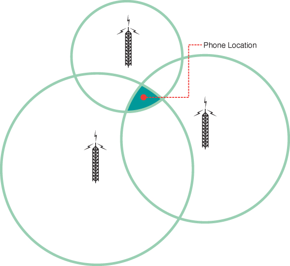
Cell tower location uses triangulation
against multiple cell towers to pinpoint the phone’s location based on
the ping time from each tower. The distance from a single cell tower
can be roughly determined by the time it takes for a phone to respond
to a ping. The location of the cell towers combined with their ping
times allows the phone’s location to be pinpointed (see Figure 2).

FIGURE 2 A phone’s location can be pinpointed using cell tower triangulation.
Accuracy increases as more towers are included in the calculation.
Although cell tower
triangulation uses less power than A-GPS, it is less accurate. Cell
tower triangulation works best where there are more cell towers. Thus,
areas such as city fringes or countryside may not provide an adequate
level of accuracy. Unlike A-GPS, however, cell tower triangulation
works indoors.
Wi-Fi Triangulation
Wi-Fi triangulation provides a middle ground
between A-GPS and cell tower triangulation. Wi-Fi triangulation uses
less power than GPS and can provide better accuracy than cell tower
triangulation in some environments.
Wi-Fi location relies on a global location
database of Wi-Fi networks and the ability of a phone device to detect
Wi-Fi networks within its vicinity.
Wi-Fi triangulation works by detecting
networks that are in range, measuring the signal strength of each
network, and then triangulating the result using the Wi-Fi network
location database.
Note
The Wi-Fi network location database
is provided by the company Navizon; currently, no public API exists for
accessing the data directly.
Geographic Location Architecture
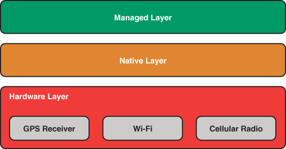
The Windows Phone location architecture
consists of three layers: a hardware layer, a native code layer, and a
managed layer (see Figure 3).

FIGURE 3 Location architecture layers.
The hardware layer comprises the location
related hardware components in the phone device, which includes a GPS
receiver, a Wi-Fi interface, and a cellular radio. Each serves as a provider of location information with varying degrees of accuracy and power consumption.
The second layer, a native code layer,
communicates directly with the hardware devices to determine the
location of the device. The choice of hardware component, or
combination of components, depends on the accuracy level requested by
the app and the availability of data; there may not be any Wi-Fi
networks in the vicinity, for example.
The native code layer also uses a Microsoft web service to provide location related information from a database.
Code cannot be written to directly
interact with the native layer, nor the hardware layer.